
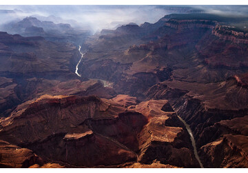
Grand canyon’s origin resolved? Ancient lake's flood may have etched famed gorge
Mineral grains show Colorado River filled a basin at the canyon’s head millions of years ago
It’s a debate that seems nearly as old as its subject: How did the Grand Canyon, that most charismatic of megalandscapes, come to be?
New evidence published today in Science, suggests some 6.6 million years ago, the Colorado River, which had not yet reached the sea, began to empty into a deep lake just upstream of the future Grand Canyon. Once these waters rose high enough, they could have overtopped a high plateau that blocked their westward progress. Like water breaching a dam, the event would have released a torrent that over time carved the canyon.
The clues, from lake-bottom sediments and outcrops that could mark the ancient shore, are “clear evidence that the lake existed and it was fed by the Colorado River,” says co-author Ryan Crow, a geologist at the U.S. Geological Survey. “The lake must have played a major role in the formation of the Grand Canyon.” Rebecca Flowers, a geochronologist at the University of Colorado (CU) Boulder, says Crow and his colleagues “make a reasonable case that lake spillover can explain the data,” but it’s still possible the water took a different route.
It’s long been known that the Colorado sculpted the Grand Canyon in its modern form, with its sediments appearing downstream of the canyon as recently as 4.8 million years ago. Its role has remained secure even as geologists have come to think that some parts of the canyon are far older, carved by earlier rivers as long as 70 million years ago, in the age of the dinosaurs.
But ever since John Wesley Powell’s 1869 expedition, the central question has been how the Colorado managed to reach the Grand Canyon at all—given that its path cuts straight across the Kaibab Plateau, the highest region in this part of the Colorado Plateau, which should have blocked its westward flow.
Early geologists proposed that a westward flowing river already existed when tectonic forces lifted the Colorado Plateau. As the terrain rose, the river cut its way backward through the plateau—eroding upstream until it captured the Colorado. Later work pointed to a different scenario: that the river system formed in the opposite direction, advancing from east to west in a series of “fill and spill” stages, as water pooled in basins and overtopped their rims.
One of the largest of those lake basins lies just east of the Kaibab: the Bidahochi Basin. If the ancient Colorado flowed into the basin and the water rose high enough, it might have spilled over the Kaibab and carved westward. But there was no evidence the Colorado fed the Bidahochi, and shoreline markers showed the lake only reached about 2000 meters in elevation—roughly 300 meters too low to overtop the Kaibab.
Two co-authors on the new paper, John Douglass of Paradise Valley Community College and Brian Gootee of the Arizona Geological Survey, took a new look at a mesa at the edge of this paleo-lake. There, they identified outcrops of beachrock—shoreline deposits turned to stone—at elevations of 2250 meters, close to what was needed to surmount the Kaibab.
Still, they needed evidence that the proto-Colorado had filled the basin. To get it, Crow and the other co-authors sampled the Bidahochi sandstones—rock formed from the lake-bottom sediments—at 19 sites. They dated some 3600 zircon mineral crystals trapped in the rocks by measuring the radioactive decay of trace amounts of uranium into lead. Zircon ages can serve as a river’s fingerprint because they reflect the upstream rocks that were the source of the sand. About 6.6 million years ago, that fingerprint abruptly shifts to match the Colorado’s. At the same time, the amount of sand entering the basin surged.
The study makes a compelling case that the Colorado filled the Bidahochi, Flowers says, but it doesn’t prove the spillover scenario. The Colorado might have reached the canyon when water from a shallower lake tunneled beneath the plateau, or when a river west of the plateau gradually cut upstream through it.
Matthew Heizler, a geochronologist at the New Mexico Institute of Mining and Technology, questions whether the Bidahochi outcrops represent a past beach. Yet in a forthcoming paper, he and his colleagues report new evidence that links the basin to the canyon: minerals in downstream river deposits that indicate Bidahochi sands entered the river by 4.8 million years ago. “It’s the best smoking gun I’ve seen in terms of making this connection,” he says. The researchers argue that notches in the Kaibab would have allowed waters in the Bidahochi to reach the canyon without rising as high as Crow and his co-authors claim. But neither group knows exactly what happened during the nearly 2-million-year-long gap between the Bidahochi filling and its sediments first appearing in the canyon.
The new picture of the canyon’s origins also leaves open the question of where the upper Colorado flowed before reaching the Bidahochi, adds Jon Spencer, a geologist at the University of Arizona who reviewed the Science study. Fish fossils in the basin resemble species found in ancient Lake Idaho, hinting that the river once drained northward into the Snake River system and flowed toward the Pacific Northwest—before volcanic activity associated with the Yellowstone hot spot rerouted it south.
For Crow, contributing to the story of the canyon’s origin is a homecoming of sorts. Before becoming a scientist, he worked at CU, creating interactive displays for the public—including one on the Grand Canyon. It was a river trip down the canyon that made him want to become a geologist. “I was blown away,” he says. He hopes future visitors will be inspired to learn a new story about its creation. “People seem to be interested in geology when they’re in front of the Grand Canyon,” he says. “It’s a teachable moment.”
science.org